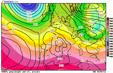
Sea level pressure (black lines) and geopotential height at 500 hPa (solid colours), next Sunday at 00 UTC. Credit: MeteoSIM.
30.06.11. Here is a new weekend and some changes in weather are forecasted for the Costa Tropical granadina. I’m going to tell you.
Synopsis: weather forecast runs are pointing to some little changes in weather that will take place in our Costa Tropical next weekend. In this way, a shortwave trough is forecasted to move over the Iberian Peninsula by Sunday; this kind of atmospheric pattern is associated to moderate to strong west-southwestern (WSW) winds along the coastal-line of our region. Then, we can expect moderate to strong WSW winds by Sunday, since midday. Anyway, lets go with the details:
Tomorrow: low clouds could reach the coastal-line in the morning. Moreover, some cloudiness at medium & high levels is expected, dissipating with the pass of time. Some high & medium level clouds could persist after that. Wind will blow firstly from the NE, especially along the main valleys and the coastal-line. At middle morning it could turn to ESE, with some moderate gust. Since the afternoon, a diurnal breeze regime could stablish, with weak southwestern wind, along the coastal-line, S inland, weak as well.
TEMPERATURE IN SALOBREÑA: MIN.: 20ºC – MAX.: 25ºC
Sea surface temperature (coastal waters): 23ºC
Sunday: few clouds or no clouds in the sky. The shortwave trough at high levels will be crossing over the Iberian Peninsula, so there will be some changes in wind speed and direction. In this way, wind will blow firstly from N, weakly, especially along the main valleys and the coastal-line. With the pass of time it will turn to WSW, especially along the coastal-line, blowing moderately and even strongly. There will be a high chance that it will turn to NW at last. It means that it could suffer an adiabatic compression over some places of our region, with quick temperature rises (it is very difficult to forecast).
TEMPERATURE IN SALOBREÑA: MIN.: 19ºC – MAX.: 24ºC.
Sea surface temperature (coastal waters): 23ºC
Don’t forget to take a look to the page on Facebook for the last updated data. You can leave there your comments and photographs if you want it.
![]()
Non-official weather forecast developed by Pedro C. Fernández. Based on several weather runs outputs. The Weather Station of Salobreña – Beah, provides its data online on Internet: www.cazatormentas.net/salobrena.html It is sponsored by “Freiduría ‘El Rey del Boquerón’” Restaurant, Hostal Palomares ** (www.hostalpalomares.com), “El Forajido” Restaurant (www.restauranteelforajido.com), Seafood/Shellfish Restaurant «El Trasmallo», the Patisserie/Ice-Cream parlor “Delicias del Rey Fernando”, the exclusive Clothing Store BOHEMIA, Mª José Parapharmacy (in front of the Mercado Municipal), all business of Salobreña, and the Chiringuito «El Último» in Torrenueva.
The copy of this weather forecast is forbidden.


Tú opinas